Thursday, December 20, 2012

Through Leicester, up Foxton and down to Blisworth


Having slipped unobtrusively through Leicester's northern suburbs, we came along the 'Mile Straight', as the canal and River Soar make their joint presence felt.  Soon we would leave the river behind, but they are combined along this section, with the river seeming to join and leave as we travelled south through the rest of the city.


Some windows of these old warehouses had lights burning – good to see that they were still being used!


Leaving the city behind, we enjoyed a steady climb up about a dozen locks through the countryside near Newton Harcourt.


It was mid-October – autumn colours were everywhere!


After more dawdling, through Saddington Tunnel.  You can just see the other end – it's just half a mile long.


Then, when we had moored below Foxton locks, another boater said we had tied up in his favourite spot – and we soon saw why!


A misty morning on the Market Harborough arm,


 and Foxton Locks with the lock cottage looming on the skyline.


David and Mary (on a short visit with Whisk and Jester) working up the locks –


 though we had to wait halfway for an unscheduled stoppage as the lockgates were being pressure-washed.  We were told there was an open day approaching!


Leaving Husbands Bosworth tunnel on the return to Foxton, taking David & Mary back to their car.


Colourful spindle tree fruits in the Crick Millennium Wood.


An old friend spotted at Crick!  'Charlton' was the narrowboat in which we had a share from 2004 to 2006.  It was our holidays in Charlton which re-started our love of the waterways.  Still in shared ownership, but now with a gleaming new paint job.  Hardly believable that she was built about 20 years ago!


Looking back up Watford Locks – our last narrow locks of the year!


A bright November morning as we pass near Bugbrooke on our way to our winter mooring in Blisworth Marina.


Ice on the water, frost in the trees – the view from Zindagi on a crisp December day . . . but, with both central heating and our woodburner, we're nice and cosy inside!

Wednesday, November 21, 2012

Down to the Trent – and up the Soar


Back in late April, we had come through Great Haywood on our way northwards to Stoke-on-Trent, the Caldon Canal and points north.  Now, at the end of September (yes, the blog is still out of date!), we were rejoining the T&M to head back south – but by a slightly different route! 

Signs of Autumn!  Well, it was very nearly October!

Having travelled generally south-east from Stoke, the Trent & Mersey takes a right angle bend near Fradley and starts heading north-east.  So, although we were travelling southwards, our route would take us northwards for quite a few miles!

Fradley Junction and 'The Swan'.  We had arrived here from the Coventry Canal in April, joining the 'T' junction from the left of the picture.  Now we were following the T&M to where it joins the River Trent, so we passed straight on and down the locks.

It was actually only about 2 miles before we had a brief 'brush' with the Trent.  Near Alrewas, the canal is joined by the river (under the bridge to the left of the picture) for just a few hundred yards.  Sometimes high river levels close this section, but we were OK.

After a two-mile noisy straight section of the canal, where it runs next to the old Roman Road known as Ryknild Street (now the A38), we enjoyed the pretty surroundings of Tatenhill Lock.

Through Burton-on-Trent and on to Shardlow.  This is the old (18th century) Trent Mill, where boats used to enter to unload.  Nicely restored more than 30 years ago, but not for commercial boat traffic, it is now a pub!

Just a mile and one lock further on, the River Trent joined us from the south under this new bridge, built to replace the original 'Longhorse Bridge', which actually crossed the river from the point where the photo was taken!  This is a real '4-way' junction, as the canal comes from the west, the (un-navigable) River Derwent joins it from the north (directly opposite the Trent) and then the waterway continues eastwards under the M1 towards . . .

 . . . Sawley Marina, with the cooling towers of Ratcliffe-on-Soar power station beyond.  This busy marina is on a 'cut' separated by flood locks from the main flow of the river.

About a mile further on, we passed an even more complex junction – the 5-way junction at Trent Lock, where the Erewash Canal branches north, the River Soar joins from the south, and both the Cranfleet Cut to Nottingham and the River Trent head off eastwards.  Again, this can be hazardous in high water conditions, especially as the flow of the two rivers tends to push boats towards the Trent, which immediately plunges over the large Thrumpton Weir!  Water flow was OK as we went through, so no problems – apart from one crazy boat skipper who came down the Soar MUCH too fast, creating a potentially unsettling wash!

Entering the Soar Navigation, we were reminded again of its endearingly quirky character, almost as if we had stepped back in time, with simple rural boatyards and boats of all shapes and sizes.

A misty morning near Zouch (apparently pronounced 'Zoch'), with seagulls on the emergency moorings and the spire of Normanton-on-Soar on the skyline.

We were definitely in 'dawdling mode' now!  We were due back in Blisworth in early November, and it was now early October – lots of time!  We had allowed for possible delays caused by high river levels but so far had faced no problems.  But we were still on a river and were reminded by the level indicators that the Soar WAS a little high – in the amber, not the green, and sometimes very close to being in the red!

Loughborough, though, sits on a 'canal' section.  We needed to do some shopping, and so chugged into the Wharf (with the brightly painted Travelodge!), then turned around and moored up slightly further out of town.

Virginia Creeper climbing up a house with two ground floors – one at towpath level, the other level with the road as it crosses Nottingham Road Bridge.

Back on the river 'proper', and the Soar looking its tranquil self – but the weirs were still running well!

Looking back to Barrow Deep Lock.  The green light confirms that the river section below is safe to navigate.  Just as well – we had just come off it!

On to Mountsorrel and under its impressive brick 'conveyor' bridge (1860).

Junction Lock, near the junction of the Melton Mowbray Canal and Oakham Canal, closed in 1877 but with some recent talk of restoration.

We planned to travel through Leicester in one day, and so stopped north of the city, near Syston, at the Hope and Anchor pub.  We enjoyed Sunday lunch after a walk in the nearby Watermead Country Park – with some very photogenic teasels!

Wednesday, October 24, 2012

September on the Shroppie – and the Staffs & Worcs


Nantwich is just a couple of miles south of Hurleston Junction, where we had rejoined the Shropshire Union from the Llangollen, but we stopped here for a few days to get a replacement circulating pump for Zindagi's central heating.


Audlem is a few miles further on, with its narrow locks in pleasant surroundings,


 the 'Shroppie Fly' pub, an old wharf crane and the former Audlem Mill,


 before the rest of the flight really gets climbing up out of the Cheshire plain to the Shropshire heights – an overall climb of 93 feet in 15 locks.


So, who is this member of the Mafia driving our boat??  Oh, don't worry, it's only Val wearing her sunglasses and the hat that Shireen and Thor gave her!!


Up another 31 feet in the 5 Adderley locks . . .


 . . . and 33 feet more as 5 locks at Tyrley cut up through the red sandstone.


The High Bridge in Woodseaves cutting a mile or so later, typical of the Shropshire Union.  Earlier canal engineers might have taken a detour round the hill – not Thomas Telford!


First signs of approaching autumn – the boat starts collecting leaves!


Another deep cutting, another High Bridge!  This one in Grub Street cutting with its iconic stub of a telegraph pole on the bracing arch.  It used to carry phone wires, but not any more.


Norbury Junction near Stafford doesn't look much like a junction at the moment, but this little arm is the beginning of the Newport Branch which used to connect right through to Shrewsbury.  There is talk of restoration, but when?


More of Telford's engineering.  The Stretton aqueduct over the A5 (Watling Street).  The inscription labels this as the 'Birmingham and Liverpool Canal' with Thomas Telford as the engineer and dated 1832.


Getting further south and within earshot of the M54, heron and ducks enjoy the morning sunlight.


As we approached Autherley Junction and the 'Staffordshire and Worcestershire Canal' (understandably abbreviated to 'Staffs & Worcs'), we needed to decide whether to turn right and head south to visit Stourport again, or simply turn left and head north-east to Great Haywood.


We turned left!  A few miles up the Staffs & Worcs, we passed through Gailey, where the lock drops the canal down under Watling Street.  Next to the unusual Round House, where the lock keeper used to live and was able to see boats arriving from either direction and prepare the lock accordingly.


Just before Haywood Junction with the Trent and Mersey, we moored in Tixall Wide and were treated to this sunset! 

Friday, October 19, 2012

A Month on the Llangollen


Our first trip on the Llangollen Canal was just 10 days or so after we started our canal travels back in 2007.  The boat still felt new, we were still getting used to it, and David & Mary had joined us for the only time they could make it – Easter school holiday week!  We avoided the worst of the holiday crowds by starting a few days later than they did, and we still made it up to Llangollen and back in a week!

No such pressure of time on this occasion, but when were we going?  Only in August – school holidays again!


The Llangollen, of course, is known for its distinctive style of lift bridge.  Here is one near Wrenbury which we didn't need to operate – it is left permanently open.


The hedgerows were responding to warm sunshine, at last!  Hemp Agrimony near Wrenbury.


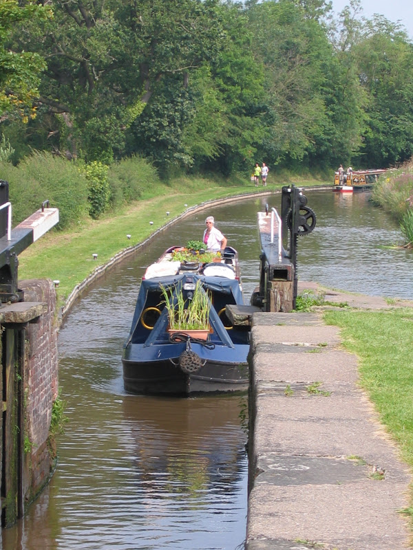
Val bringing Zindagi into Quoisley Lock, on the Cheshire/Shropshire border.  This canal was originally known as the Ellesmere Canal and runs through several miles of Cheshire and Shropshire countryside before it get anywhere near Wales!


Near Ellesmere, we moored right next to Blake Mere.  This was very nearly the view out of our bedroom window!


Down the short arm to Ellesmere itself, the stark emptiness of the wharf is relieved by the old crane and canal warehouse – neither in use for anything as far as we could see!


New Marton Locks, just about the only significant congestion point we have found on the canal.  This time, we only had to wait about half an hour to get into the lock – but look at the queue of boats behind us – I make it about 7 or 8!


Then, an apparently sudden transition to the Welsh Hills as we crossed Chirk Aqueduct next to the railway viaduct.  This aqueduct would probably be much more famous if it wasn't for the other one just 3½ miles away!


And here it is – the jaw-dropping view, looking straight down over the side of Zindagi's stern deck, to the River Dee, some 120 feet below the Pontcysyllte aqueduct.


See what we mean?  The nearest thing to flying in a narrowboat!  And, amazingly, we had come up no more locks since New Marton in Shropshire.  Perhaps not so much climbing into the Welsh Hills as soaring over the Welsh valleys!


We arrived in Llangollen 8 days after we joined the canal, and decided to stay 2 nights in the mooring basin.  A moderate charge for a quiet location, with electrical hook-up included.


The canal from Trevor to Llangollen was originally designed only as a feeder, but was made navigable this far.  Only the shallow-bottomed tourist trip boat can go any further . . .


 . . . but we walked up to Horseshoe Falls, where the feeder comes off the River Dee, not only keeping the canal supplied but also feeding Hurleston reservoir at the junction with the Shropshire Union.


Here is the Chain Bridge Hotel at Berwyn, perched on the banks of the Dee with the canal feeder hidden behind it and the old suspension ('chain') bridge still standing (but not in use!)


We walked over the road bridge and up the other side of the valley to little Berwyn station, to catch the Llangollen Railway back.


Our train was pulled by a historic diesel, but we met a steam engine coming the other way,


 back to Llangollen station.

Castell Dinas BrĂ¢n towers over Llangollen and is the remains of a medieval fort, as well as the site of an ancient Iron Age hill fort.  A good morning climb for Dave, rewarded with stunning views!  The canal basin is just to the right of the large white Eisteddfod marquee, but not really visible from up here!


As we made our way back, here is a different view of the Pontcysllte aqueduct, from the bridge over the Dee below.  Yes, that IS someone walking over on the footpath!

Just a few miles from the aqueduct, we turned off at Frankton Junction to spend a few days on the Montgomery Canal.  Progress on restoration seems to be slow, but recently lottery funding has been going elsewhere, apparently!

Apart from simply enjoying another visit to the 'Monty', we had other motives for coming here!  The Navigation Inn (a former canal warehouse in Maesbury Marsh) was the venue we had chosen for a family meal to celebrate our 40 years of marriage,


 closely followed by an afternoon's canoeing for the whole family . . .


 . . . and not forgetting a cuppa and ice cream afterwards!  Thanks to Adam for hosting us all.  Another reason for choosing Maesbury Marsh – Shrewsbury is not very far away!


Shireen and Thor joined us for a few days afloat – over the Pontcysllte aqueduct again!


We left the Llangollen Canal on the 8th of September, exactly a month after we joined it.  A most enjoyable month – now to head further south!